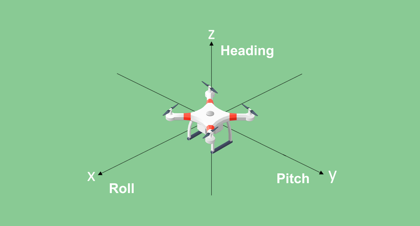
For surveying or GIS, positioning data can meet the demands. But for some navigation applications such as auto-steering systems for agricultural operations or guiding UAVs, it is crucial to get the orientation information. We primarily describe this orientation using three parameters: pitch, heading, and roll. Roll refers to rotation around the X axis, pitch is rotation around the Y axis, and heading denotes rotation around the Z axis (as illustrated in the accompanying image).
In this blog, we will introduce the #heading data and how it plays a pivotal role in our modern world.
NMEA Log and Standard Heading Format
In the context of NMEA (National Marine Electronics Association) logs, there's a specific log entry for heading, aptly named the HEADING log. The standard format for geolocation information represented by $HEADINGA is as follows:
#HEADINGA,COM1,0,60.0,FINESTEERING,2281,384415.000,00000000,0000,1114;SOL_COMPUTED,NARROW_INT,13.425773621,67.686813354,-78.931716919,0.000000000,0.212850377,0.413018167,"0004",16,15,16,16,0,0,4,107*157ecb94
Breaking down the fields:
Meaning of Each Field
|
Field 1 | Solution status |
SOL_COMPUTED | Solution computed |
INSUFFICIENT_OBS | Insufficient observations |
COLD_START | Not yet converged from cold start |
Field 2 | Position type |
NONE | No solution |
FIXEDPOS | Position fixed by the FIX POSITION command |
SINGLE | Single point position |
PSRDIFF | Pseudorange differential solution |
NARROW_FLOAT | Floating narrow-lane ambiguity solution |
WIDE_INT | Integer wide-lane ambiguity solution |
NARROE_INT | Integer narrow-lane ambiguity solution |
SUPER WIDE_LINE | Super wide-lane solution |
Field 3 | Baseline length (0 to 3000m) |
Field 4 | Heading in degrees (0 to 360.0 degrees) |
Field 5 | Pitch (-90 to 90 degrees) |
Field 6 | Reserved |
Field 7 | Heading standard deviation in degrees |
Field 8 | Pitch standard deviation in degrees |
Field 9 | Station ID string |
Field 10 | Number of observations tracked |
Field 11 | Number of satellites in solution |
Field 12 | Number of satellites above the elevation mask |
Field 13 | Number of satellites above the mask angle with L2 |
Field 14 | Reserved |
Field 15 | Extended solution status (default: 0) |
Field 16 | Reserved |
Field 17 | Signals used mask |
The Importance of Heading
Heading is a fundamental metric utilized in various domains such as aircraft navigation, marine navigation, and drilling operations. One effective method to determine heading involves employing a dual antenna receiver. By comparing the positions of two antennas, this receiver calculates the angle from True North of one antenna to another antenna vector in a clockwise direction—this calculated angle is the heading. Notably, the accuracy of the course can be significantly enhanced by increasing the distance between the two antennas. The longer the antenna distance, the higher the heading accuracy achieved.
The SV100 DUAL: Providing Reliable Heading Information
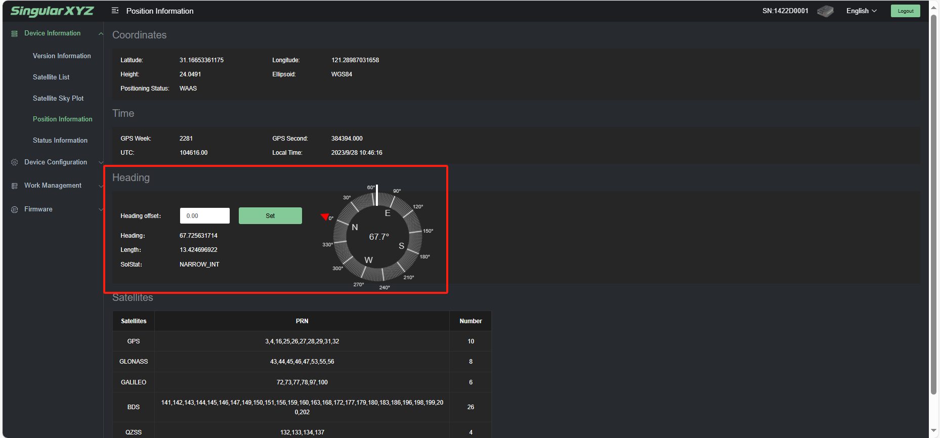
Our SV100 DUAL system offers a seamless solution for obtaining accurate heading information. Simply connect the two antennas to the SV100 receiver and access the heading information through the intuitive WebUI. During the initial stages, the heading angle might exhibit slight fluctuations. However, as time progresses and the system stabilizes, the heading angle converges to a consistent and reliable value.
Understanding and utilizing heading information is pivotal in enhancing navigation precision across diverse applications, ultimately contributing to safer and more efficient operations.
Learn more about SV100 dual:
https://www.singularxyz.com/SV100_Dual.html
Learn more about SingularXYZ solutions:
https://www.singularxyz.com/product


 Home
Home